Advertisement


Private equity has played a significant role in shaping Indi...
In today’s real estate landscape, fitness is often treated...
In this episode of Prop Personalities, we sit down with Hars...
Luxury real estate is one of the most talked-about segments ...
Welcome to Prop Personalities by Prop News Time - a podcast ...
The Delhi government is planning to construct a nearly 5-km flood protection wall along the Yamuna river between Majnu Ka Tila and Kashmere Gate to safeguard low-lying neighbourhoods in north Delhi from recurring monsoon flooding. The project, estimated to cost around INR 50 crore, has been approved by the Yamuna Standing Committee and will run largely along the Ring Road corridor. The proposed structure will extend about 4.72 km and include sections of reinforced cement concrete in high-risk areas and masonry barriers along the remaining stretch. The wall is designed to rise roughly six feet above the anticipated maximum flood level to prevent river water from entering nearby residential and commercial zones. The initiative follows the severe flooding of 2023 that affected several parts of north Delhi and disrupted traffic and daily activity in the capital.
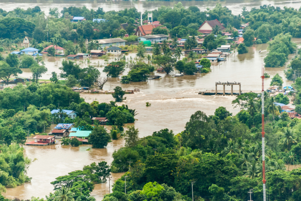
The Delhi government is planning to construct a flood protection wall along the Yamuna river in north Delhi to reduce the risk of monsoon-related inundation in vulnerable urban areas. The project, which involves building a barrier extending nearly 5 km between Majnu Ka Tila and Kashmere Gate, has been cleared by the Yamuna Standing Committee and is estimated to cost about INR 50 crore. The structure will run largely along the Ring Road corridor and is intended to protect nearby neighbourhoods from river overflow during periods of high water levels. Advertisement


According to project details, the proposed flood wall will cover a stretch of approximately 4.72 km. Of this, about 850 metres in sections identified as high-risk flood zones will be constructed using reinforced cement concrete, while the remaining 3,870 metres will consist of brick or stone masonry barriers. The wall will be designed to stand roughly six feet above the expected maximum flood level to create a safety margin and prevent floodwaters from entering adjoining urban areas.
The project is part of broader flood-management measures being considered by authorities in the capital after severe flooding occurred in 2023. During that episode, the Yamuna river breached embankments and inundated several localities including Civil Lines, Yamuna Bazaar and Majnu Ka Tila. The flooding also disrupted traffic on the Ring Road and affected residential and commercial activity across parts of north Delhi.
Officials indicated that the flood wall is intended to function as a physical barrier to prevent river water from entering low-lying zones during periods of high discharge. In addition to protecting residential areas, the structure is expected to reduce the risk of erosion along the riverbank and discourage encroachments along vulnerable stretches of the floodplain.
The proposed wall will be built close to one of the city's major transport corridors, making the project significant for maintaining traffic movement during flood events. The Ring Road runs parallel to parts of the Yamuna and connects several key neighbourhoods and commercial districts in the northern part of the capital. Flooding along this corridor has previously caused major disruptions to daily commuting and logistics movement.
Authorities have already issued tenders for the project, though an exact construction timeline has not yet been announced. The flood wall initiative forms part of a wider strategy by the Delhi government and associated agencies to improve flood preparedness and strengthen riverbank protection measures along the Yamuna.
Urban planners note that flood-control infrastructure is becoming increasingly important for the capital as extreme rainfall events and rising river levels continue to pose risks to low-lying areas. The planned barrier is expected to complement other measures such as strengthening embankments, improving drainage networks and enhancing monitoring of river levels during the monsoon season.

5th Jun, 2025

25th May, 2023

11th May, 2023

27th Apr, 2023
Advertisement


 Facebook
 Whatsapp