Advertisement


Private equity has played a significant role in shaping Indi...
In today’s real estate landscape, fitness is often treated...
In this episode of Prop Personalities, we sit down with Hars...
Luxury real estate is one of the most talked-about segments ...
Welcome to Prop Personalities by Prop News Time - a podcast ...
Bengaluru Smart Infrastructure Ltd (B-SMILE) has invited bids for consultancy services to accelerate five elevated road projects spanning almost 80km. The corridors are planned to improve east-west and north-south connectivity while diverting through traffic from congested city roads. Key stretches include Nagavara to Bagalur, Mother Teresa Circle to Bagalur village, Old Madras Road to Electronics City, Sirsi Circle to Nayandahalli, and Kanakapura Road. Detailed project reports are ready, and selected consultants will handle project management, technical vetting, and proof-checking to ensure timely and high-quality execution.
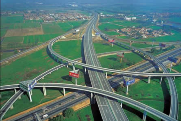
Bengaluru is set to move forward on a major infrastructure initiative with tenders floated for consultancy services on five elevated corridors covering nearly 80km. The move, led by Bengaluru Smart Infrastructure Ltd (B-SMILE), aims to reduce chronic congestion on the city's busiest routes and strengthen east-west and north-south connectivity. Eligible project management consultants (PMCs), DPR consultants, and proof-checking agencies with relevant experience have been invited through a two-cover system on the Karnataka Public Procurement portal. Advertisement


One of the primary projects is a 17.9 km six-lane elevated corridor from Nagavara Junction to Bagalur Main Road, passing through RK Hegde Nagar, Sampigehalli, Tirumenahalli, and Bellahalli. The flyover will extend from Sathnur village to Chokkanahalli village, with the DPR prepared by Infra Support Engineering Pvt Ltd. This corridor is expected to relieve significant congestion on the northern commuter route.
The second corridor targets the city's heavily trafficked north-eastern section with a 27.1 km elevated road connecting Mother Teresa Circle near Ulsoor lake to Bagalur village on the new airport road. The alignment crosses Assaye Road, Buddha Vihar Road, Hennur Main Road, Bagalur Main Road, and Kannuru areas notorious for peak-hour bottlenecks. Infra Support Engineering Pvt Ltd also prepared this DPR.
To address pressure on eastern and southern corridors, a 10.8 km elevated route is planned from Old Madras Road to Electronics City flyover. The route passes through Swami Vivekananda Metro station, Indiranagar, Old Airport Road, Hosur Road, and Silk Board Junction, one of Bengaluru's most congested choke points. The DPR for this project was prepared by Siddhi Shakti Projects.
In west and south Bengaluru, two additional corridors have been proposed. The first is a 5.2 km elevated road from Sirsi Circle to Nayandahalli on Mysuru Road, extending toward the Mysuru Satellite Bus Station. The second is an 18.4 km stretch along Kanakapura Road from Marenahalli Main Road (Ragigudda Junction) via the BWSSB Pipeline Road near Thalaghattapura 5th Junction, with the DPR prepared by Nagesh Consultants. Both are intended to reduce traffic on heavily saturated arterial roads.
Officials have stated that selected consultants will oversee project management, technical vetting, and proof-checking to ensure the corridors are executed efficiently, safely, and on schedule. This step is crucial to transforming detailed project reports into actionable infrastructure, with potential long-term benefits for daily commuters. The initiative complements broader traffic relief strategies across Bengaluru.

5th Jun, 2025

25th May, 2023

11th May, 2023

27th Apr, 2023
Advertisement


 Facebook
 Whatsapp