Advertisement


Private equity has played a significant role in shaping Indi...
In today’s real estate landscape, fitness is often treated...
In this episode of Prop Personalities, we sit down with Hars...
Luxury real estate is one of the most talked-about segments ...
Welcome to Prop Personalities by Prop News Time - a podcast ...
The Brihanmumbai Municipal Corporation (BMC) has initiated an aquifer mapping project along the Mithi river basin to enhance groundwater management. The initiative, launched earlier this week, will be carried out over 18 months with assistance from the Central Ground Water Board (CGWB). The project aims to assess groundwater availability, quality, and recharge potential using satellite data, soil testing, and geophysical studies. As part of the city's larger water sustainability plan, this effort will inform future decisions on water resource conservation and urban flood mitigation.
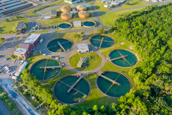
An extensive aquifer mapping project throughout the Mithi river basin has been started by the Brihanmumbai Municipal Corporation (BMC) in an effort to enhance groundwater management in Mumbai. This exercise, which began earlier this week, is being undertaken in collaboration with the Central Ground Water Board (CGWB), under the Ministry of Jal Shakti, and is expected to be completed over a span of 18 months. Advertisement


According to civic officials, this is Mumbai's first such project aimed at identifying groundwater reserves, analysing recharge zones, and evaluating aquifer behaviour in urban settings. It is part of a broader vision to enhance the city's water resilience, particularly as surface water sources come under increasing stress due to climate change and urban expansion.
The mapping project will cover approximately 30 square kilometres, spanning key areas around the Mithi river. The data will be compiled through satellite imaging, soil testing, and geophysical surveys to determine the volume and quality of available groundwater. An official mentioned that the outcome will assist in identifying potential recharge zones and planning sustainable water usage for the long term.
The CGWB has taken the lead in technical aspects, while BMC has offered logistical support. The study also aligns with the city's flood mitigation and integrated water management plans. Past flooding incidents have already prompted civic authorities to consider underground water storage and smart aquifer systems as potential buffers.
Officials stated that this baseline data would play a critical role in creating a scientific groundwater model for Mumbai and potentially for other urban centres facing similar water stress. The model will include detailed hydrogeological parameters, water quality trends, and recommendations for better aquifer recharge practices, particularly in heavily concretised zones.
The mapping results will also help BMC frame policies related to borewell permissions, construction regulations, and rainwater harvesting, further promoting sustainable urban development.
By establishing a data-driven understanding of groundwater behaviour in the Mithi river basin, the city can develop adaptive strategies not just for water conservation, but also for reducing flood risks and improving urban resilience. This proactive approach could serve as a model for other metropolitan areas grappling with similar challenges.

5th Jun, 2025

25th May, 2023

11th May, 2023

27th Apr, 2023
Advertisement


 Facebook
 Whatsapp